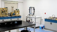
This course is a hands on course on GIS: two weeks of practical's in the GIS Lab of the faculty of Geosciences. The following topics will be covered:
• Working with ArcGIS desktop (ArcInfo) and Spatial-Analyst (data input, analysis and presentation)
• Automatic DEM extraction of aerial photographs using ERDAS Imagine Leica Photogrammetry suite 2011 (ATE and eAte)
• Mobile GIS / GPS with ArcPad 10
• Local and Global Geo-datasets (GIS, remote sensing)
• Poster makingSoftware and data are also available for students to work at home (laptop).
Period
08-07-2013 - 19-07-2013 (2 weeks)
Target group
Upper year (3rd/4th) bachelor students in the fields of earth sciences, geology, physical geography or related areas of study. Basic academic knowledge in physics/ mathematics is strongly recommended
Course aim
To familiarise students with working with geospatial data and software for landscape analysis on a local and global scale.
Credits
3.0 ECTS credits
Certificate of Attendance
Course fee
EUR 895: Course + course materials + housing
EUR 560: Course + course materials
Course leader
drs. Maarten Zeylmans van Emmichoven
Scholarships
Utrecht Summer School doesn't offer scholarships for this course.
Utrecht University
Address: PO BOX 80148
Postal code: 3508 TC
City: Utrecht
Country: Netherlands
Website: http://www.utrechtsummerschool.nl
E-mail: summerschool@uu.nl
Phone: 0031302534400
Hands-on GIS for Earth Scientists
label
Diverse
calendar_month
2013-01-07, 00:00
autorenew
2025-09-29, 17:00
history_edu
Diana Ignat